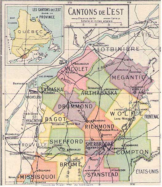
The surface thus registered represented 12,000 square miles. It was divided into 92 cantons of about 10 square miles each and that were divided into 320 batches of 200 acres. These Abenakis hunting grounds consequently became the Eastern Townships. Megantic County was divided into 9 municipalities: Leeds, Inverness, Ireland, Halifax, Broughton, Nelson, Somerset, Thetford and Tring. In 1861, Tring was no longer part of the Megantic County, and later, Somerset became part of the Arthabaska County. Broughton was transferred a little later to the Beauce County. As of 1940 what remained in the Megantic County was definitively redrawn and annexed to the new area of the Bois-Francs, from the base of the Appalachians to the Valley of the St. Lawrence.
Gwen Rawlings Barry, A History of Megantic County, Downhomers of Quebec's Eastern Townships, Evans Books, 1999, p. 2.
Megantic, a county in southern Quebec, is surrounded by the counties of Beauce, Frontenac, Wolfe, Arthabaska, and Lotbinière. The name is derived from the Abnaki word Namesokanjik, meaning "where they preserve fish." The county is traversed by the Canadian National and Quebec Central Railways; and contains important asbestos deposits. County town, Inverness. Pop. 40,357 [in 1948].